Lincolnshire prepares for emergencies with digital twins and drones
Lincolnshire County Council is using geospatial technology to help it prepare for emergencies caused by severe weather across the country.
Lincolnshire Resilience Forum (LRF) has started using image recognition and drone software from Esri UK to create real-time intelligence and an improved understanding of potential catastrophes, including floods and power cuts.
Covering over 2,000 square miles and a population of more than 750,000, Lincolnshire’s objective is to protect its residents and better prepare for an contain emergencies.
The Council said preparing for tidal inundation is a top priority due to Lincolnshire having one of the largest single land masses in the country.
The new drone software is making aerial data capture faster and more accurate, allowing LRF to create digital twins more quickly that show potential higher risk zones to understand evacuation points. They are also using digital twins to better monitor the Control of Major Accident Hazards (COMAH) locations, which involve dangerous substances such as gas and oil refineries.
“Responding to large emergencies – particularly flooding but also major transport incidents or the loss of critical infrastructure – is a crucial role of public services. With the climate crisis comes more extreme weather events, which means community resilience is even more important,” explained Steve Eason-Harris, Emergency Planning Officer at Lincolnshire County Council, who is the lead officer for GIS and Resilient Communities for the LRF.
“Lincolnshire is a large county with no motorways and few dual carriageways so response and evacuation planning is critical. These new innovations are enabling emergency planners to model risks affecting the county to maximise response, improve communication and coordination and reduce, as practicably as possible, the impacts on the wider communities of the county. Creating the new caravan dataset in particular will dramatically improve intelligence.”
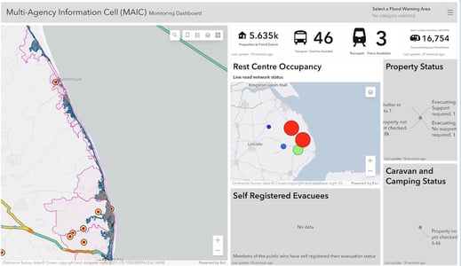
Esri's real-time mapping dashboard provides a common operating picture, which went live in summer 2022 and was used extensively during Storm Babet in October 2023. Available online, on mobile devices and giant touch screens in the County Emergency Centre, it integrates data from over 30 agencies to allow for rapid decision-making.
LRF is also developing a workforce application for deploying, tracking and communicating with volunteers in the field through a mobile app. Data from the app will also feed directly into the mapping dashboard in the control centre.
Government Transformation Magazine recently explored the growing role of geospatial data - and how the public sector can better leverage the power of place.